|
Commercial Geography |
A Higher Secondary School Commercial Geography Site |
|
World (as per class progress)
Commercial activities
Commercial or economic activities are those activities, which people adopt as a mean of livelihood. Formally these activities can be defined as,
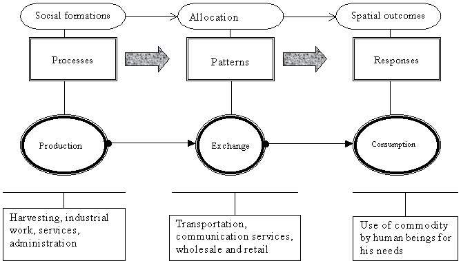
“Economic activities are a continuum of processes, their patterns and the responses that these generate.”For the sake of simplicity economic geographers divide commercial activities as follows:
1. Production
2. Exchange
3. ConsumptionProduction
Production refers to the resource generation for the commercial sector. The production sector on the basis of its technical advancement and the environment that these activities take place in, are further divided as:
Primary production
Secondary production
Tertiary production
Quaternary production
Quinary production
Primary production
This is a primitive kind of activity in which the workers employ ‘age old’ means to generate livelihood.
The examples of such activities are gathering, hunting, and subsistence agriculture etc. such activities are practiced in Congo and Amazon basin of Africa and South America. Due to the outdoor nature of these activities the workers involved in such activities are called red collar workers.Secondary production
In the secondary production sector there is a shift from primitive to industrial production techniques. Workers of various industries can be classified as secondary workers. Due to somewhat indoor nature of these kinds of activities the workers involved are called blue-collar workers.Tertiary production
This refers to the service sector in which people offers services rather that tangible good production. Workers of this sector are barbers, clerks, beauticians and secretaries. These workers are called pink-collar workers.
Quaternary production
These kinds of activities include the formal service sector in which the focus is on professional and administrative service, financial and health services and other of the type. Due the specialized environment used by the workers and the status that they hold they are called white-collar workers.Quinary production
This is the most restricted type of production sector in which the most visible are chief executives, research scientists and national policy makers. The people involved in these activities are called gold collar workers.
Fig 1. Types of commercial activities
ExchangeThe exchange services refer to the transportation and distribution of goods. It involves freight handling, retail and wholesale. The exchange services bear the following impacts on a product.
a. It increases the value of a commodity
b. It increases the scope of marketing for a product
c. It offers warehousing and distribution ease through wholesale and retail tradeThe additional value is added to a product at every stage from packaging through transport and availability at easily accessible outlets.
Consumption
This is the final aspect of all economic activities in which the product is used. This use is the response, spatial outcome or simply the consumption.
The term consumption refers to the final orect use of goods and services to satisfy the needs of users. Consumption can be broadly classified as:
Direct consumption, in which man directly employs the environment for his need like eco-tourism etc.
Indirect or gradual consumption, in which man takes a natural resource and after a complete processing reaches the consumer.Yet other standards can also be assumed for classifying consumption like on the grounds of diminishing quality and changes in value of a resource/commodity.
Effects of environment on commercial activities of man
Environment is the surrounding where one live or works. Mans environment is all that is present on the earth surface some close to him and some at a distance.
There is a marked influence of environment on economic activities of man. The economic activities are the occupations of man for a livelihood. For these man mankind mainly relies upon the environment and extract benefits from material present around him wherever and however possible.
For a geographical interpretation we can divide the environment into two types:
1. Physical environment
2. Cultural environmentPhysical environment: It refers to relief, climate, soil, water bodies’ vegetation and coastlines etc.
Cultural environment: It refers to al the man made features and there by created conditions on the face of earth. For example, political government, social customs, density and distribution of population etc.
Effects of physical environment on economic activities of man:
The deterministic approach to geography strongly claims that the activities of mankind are the result of effects of his physical environment.
The main aspects of the physical make up of a country that can have direct influence on the activities of man are as follows.
a. Shape and size of a country
b. Location
c. Topography or landform
d. Rivers
e. Coastline
f. Climate
g. Soils
h. Natural resourcesShape and size: Of a country bear direct influence on economic activities of a nation as it determines it length of border with neighboring countries, number of neighbor, climatic differences and the most important of all the length of its coastline. As in the case of Chile the long border with Argentina allows various parts of the countries to develop strong ties. Also this length to the pacific ensures the availability of a lengthy fishing ground. The country’s greater extent north south also on the other hand is a determinant of major climatic differences along the whole country and thus differing commercial produces and activities.

Maps of Canada and Chile depicting size and shape
Size of the country is also important like that of Russia, Canada and china where greater distance between places requires more investment for developing good communication networks and the like. Also being small is also considerable as in the case of Kuwait on one hand it developed a strong economy from the concentrated oil fields within its boundaries and on the other hand it still is a weak nation due to its small defense force.
Location: Location ascertains various economic activities of a country like that of Egypt at the meeting point of Mediterranean and Red Sea.
Also location renders a country its climate, frontiers and accessibility. A peninsular (with water on three sides) or insular (water bounded on all sides) country is a benefited one for fishing ports and security.
Map showing Insular Sri-Lanka, Peninsular Saudi Arabia and Landlocked Nepal
Countries land locked (covered by land on all sides) like Nepal suffers because of lack of accessibility to world market and dependence on other countries.
Topography or landform: Landmarks like mountains, rivers, plateaus and deserts are by far the most influential of physical environment on economic activities.
Mountains bear dual nature on one hand these are barriers to various economic activities like farming and town development etc. but on the other hand these are sources of minerals, rainfall water (from glaciers) and also protects from strong winds and invaders.
On plateaus economic activities are also molded as per the provided environment, like subsistence agriculture due to poor soils. But on the other hand at such place mineral resources are good.
Plains so far are the most suitable basic economic activities like agriculture and also settlement development. Mostly plains contain a good supply of water and a favourable climate for life.
Rivers: No activity can physically exist in area without people settled on a place and rivers are the most important element in developing these. Like the Tigris and Euphrates of Iraq, Indus of Pakistan and Ganges and Brahmaputra of India in Asia.
Rivers are a source of water for life these provide means of transport, irrigation, and fishing and also produce fertile plains.
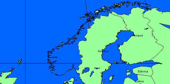
Coastline: Coastline can be an indented one providing more access to water with security against storms and can also be regular ones.
Map showing coastline of Norway
The prominent examples are those of Norway highly indented and that of African nations, which are regular. Therefore the former is with good fishing grounds.
Climate: It is extremely important in production and exchange of produce. Climate directly influences activities including production. It also influences forest distribution availability of water resources, communication networks and their development patterns and of course industries and their distribution.
Soils: Soils play a vital role in the plant life and hence directly effects activities like agriculture, forestry and herding.
Natural resources: Distribution and availability of natural resources like water, minerals and forests greatly effect economic activities of a country.
Forests provide wood for secondary production and domestic use in Amazon and Congo basins of the world. These are also supportive of gathering, hunting and primitive agriculture.It is obvious then that availability of mineral resource in an area will entail a dominance of mining in an area, as these are directly related but mining also develops path for secondary production and industrial development.
Effects of cultural environment on economic activities of man:
Cultural factors that effect commercial activities of man are:
a. Race
b. Religion
c. Government
d. PopulationRace: It refers to various ethnic groups of people living in various parts of the world all of them follow their own ways of life the South Americans are relying more on primitive mean of livelihood the North Americans and European on industrial development etc.
Religion: Though modernization has severely affected the economic activities of man in an area but still in many parts of the world religion influences various economic activities like development of cow beef centers in India and wine industries in Muslim world.
Government: Governments and their political orientation strongly influence the economic well being of a country. South Korean, Japan and China present examples of good political governments and trade policies while there also are countries with weak political framework and policies.
Population: Population builds the human resource of a nation and hence determines its economic well being but here it is a considerable factor whether a good middle age working population is present or not. Countries with good population might find it difficult to correlate policies with needs but one achieved this goal the final outcome is an excellent one like in the case of china.
Conclusion: Hence we can say that nature on one hand and our self created conditions effect almost all of our activities directly of indirectly buy nevertheless all depends on the courage and abilities of man.
Primitive economic activities
Primitive economic activities are those economic activities that very simply represent the age-old human occupations.
People can be considered primitive when their material culture is simple in its form and function, like harpoons and their use, or the rotational bush fallowing techniques.
Primitive economic activities can be classified as follows:
1. Gathering
2. Hunting
3. Pastoral Nomadism (Nomadic herding)
4. Subsistence agricultureIn about 1500 AD about half of the world population was involved in primitive activities while these days it is expected that about 5% of world population s engaged in such activities.
Gathering
Probably the most primitive form of activities that man these days perform on the face of the earth. In this kind of activities the capital investment is least and a considerable space is required. It is assumed that the people of the Semang tribe cover an average of 30 Km land in a day.Gatherers collect material for their food, shelter and clothes like berries, beans, nuts and roots and fibers from trees.
Some of the primitive tribes of the world include Semang tribe of Philippines, Chavante and Chamayura of the Amazon basin.
The living standards of primitive gatherers are very low their average health is very poor and life expectancy very short but still the strength of these people can’t be challenged.
Hunting
Primitive hunters share many common traits with gatherers but are somewhat advanced in the sense that they know how to make fire, device tools and implement their use.Hunting is a communal activity and duties are best classified as per specialization of the members. Hunters use the hide of the animal for clothing and shelter its bones to make tools like harpoons and kayaks and of course its meat as food.
The major primitive hunting environment of the world is tundra type, the frigid zone of the world. Typical of the hunting groups on earth are Eskimos of North America, Laplanders of Scandinavia and Yukaghirs of Siberia.
The sparse vegetation in tundra provides diet for musk ox and caribou, which are the major hunt. Presently only a few thousand people are associated with such occupations.
Primitive herding
It an advanced activity if seen in comparison with gathering and hunting. In this type of activity the product is animal and the investment is labor, raw labor.The herding zones of the world extend for about 8000 miles from east to west from Africa through Middle East to Asia. There are about 3.5 million herders reside in Africa, 11 million in Middle East and Asia these approximates up to a total of about 15 million.
Herding is practiced in two forms; one is the movement of herds in search of pastures from one place to another with no elevation changes while the other is vertical or relief change in search of pasture called transhumance.
Subsistence agriculture
According to the FAO (Food and Agriculture Organization) of the UN nearly 300 million people of the world practice a form of agriculture, which is only sufficient for their basic needs. Also these farmers employ the most primitive means of cultivation on earth.The various prominent types of primitive agriculture include rotational bush fallowing in which farmers cultivate only ten percent of the whole land area and leave the rest to retain its fertility through natural processes. About 75% of such cultivators live in Africa.
Fig 2. The dark portion represents cultivated zone
while the gray portion is the fallow land allowed a
rest to regain its fertility naturally.
The other form of primitive agriculture is slash and burn agriculture in which the farmers are residents of forested lands like the Amazon. In this method a part of the forest is burnt and the land exposed is cultivated but in this type the process of burning effect the productivity of land and farmers after a few years have to move onwards to a new patch.
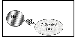

Fig 3. The circular shape shows land area cleared for
Agriculture.Other primitive farmers are the small landholders, peasant farmers and those who prefer other forms of commercial activities beside agriculture on periodic grounds.
Fishing
Fishing also is a primary activity. It involves gathering of raw material from nature. Fish is a major source of food and is the predominant source of animal protein.
Fish is captured both from fresh waters and saltwater. Marine fish capture amounts 90% of the world total fish produce, while the rest comes from freshwaters.
Physical environment
The physical environment required for fishing is more water based but still there are some considerations regarding the inland topography. A typical marine fishing environment can be studied under the following headings.
1. Climate
2. Coastline
3. Continental shelf
4. Ocean currents
5. Inland topographyClimate
Climate of a fishing ground is important of all as it determines the formation of ocean currents on one hand and the growth of edible fish types on the other hand. As obvious on the map of the world that in the Torrid Zone (equatorial) there aren’t any prominent fish producing countries to name. This also speaks for the fact that in warmer climates the fish produced is poisonous in nature. While four of the world’s major fishing zones are in the area of cold climate. Also colder the climate cheaper is the storage of fish caught.Coastline
Coastline is also an important contributor to a suitable fishing environment. Coastlines can be of various kinds but a fjord (indented) coast is the most suitable for fishing. In this way the length of the coastline increases on one hand while on the other hand the fishermen gets a place at a distance from the main ocean, slightly inland and safe from environmental hazards to some extent.

(A) Indented coast (B) Normal coast
Fig 4. Fjords coast A and a normal coast B. The first one is an example of greater coastal length. In A, a village located away from the coastal winds will be safer.
The most prominent of examples around the world in this regard is the highly indented coast of Norway.
In case of countries like Japan, which is made of three separate islands, the length of the coast is greater and thus provides more room for fishing.
Continental shelf
Continental shelf is another important attribute of the physical environment for fishing. Shallow coastal waters provide a good fishing environment and enhance the growth of planktons, which are the food for small fishes.
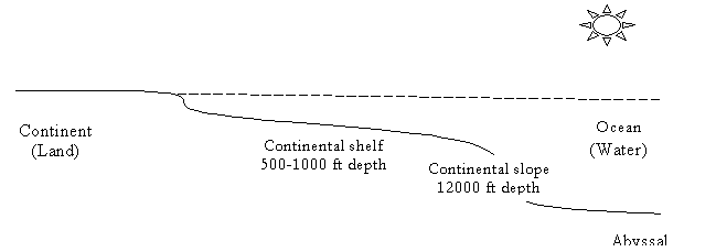
Fig 5. A schematic view of an ocean floor.
Plant nutrients thus collect well at the continental shelf and just small fraction of species live below depths more than 200 feet.Ocean currents
The upwelling of warm water like a convection cell is also important in development of a good fishing zone. It is an observation that all the world’s major fishing zones lie at sites where two major ocean currents meet.In the northwest pacific the Oija Siwo and Kuro Siwo currents meet, while in the north Atlantic to the west Labrador and Gulf Stream meet. In the south east pacific the equatorial current meets the northward moving Humboldt Current.
Inland topography
Inland topography of a country also plays an important role in development of a fishing ground. Like for example inland topography of Japan and of course its land area both aren’t sufficient to provide for agriculture, therefore fishing is a prominent occupation. Likewise in Norway the inland permafrost leaves fishing a suitable mean of livelihood.
Major fishing zones of the worldThere are about six major fishing zones of the world in terms of production and exports. The names of these fishing zones are as follows:
1. Northeast Atlantic
2. Northwest Atlantic
3. Northwest Pacific
4. Northeast Pacific
5. Southeast Pacific
6. South and Southeast Asia
Northeast Atlantic
The northeast Atlantic coast touches the northwestern European stated among which some of the prominent countries are the Scandinavian countries (Norway, Sweden and Finland) and United Kingdom. On this coast some of the other fish producing countries are France, Germany and Spain. But among all these the most prominent remains Norway. The coast of Norway is highly indented, its inland frigid and forested.
Northwest Atlantic
The eastern North American coast lies to the north west of Atlantic and it is another major fishing zone of the world. This zone of fishing has an ideal fishing environment due to the mixing of the southward moving Labrador Current with the northward heading Gulf Stream. The former is generated at northern tip of this fishing zone i.e. the Newfoundland while the later at its southern extreme the Gulf of Mexico.Northwest Pacific
This fishing zone is a region of the world leading fish producing country, Japan. With the southward moving Kamachatka current along the Siberian coast and the northward heading warm Kuro Siwo Current the growth of fish in this zone is pronounced and the catch a good one.Japan in the mid 80’s was the world leading fish producer with about 11 million metric tons of the world’s total 76 million metric tons of produce. Other fish producing countries of the region are China and the Koreas.
Northeast Pacific
This fishing zone is the northwestern North American coast, which starts from the Aleutian Islands of Alaska and extends southward up till the tip of California. It is this coast which helps a both the US and Canadian fishing industries and make them the worlds prominent fish producing countries.
Southeast Pacific
This is probably the most widely discussed fishing zone of the world because of the unique environmental phenomena called ENSO (el –nino Southern Oscillation Current). The Peruvian (of Peru) coast is an important fishing ground where two ocean Currents the Humboldt current from south and the equatorial current from north comes to meet.South and Southeast Asia
Among the south Asian and Southeast Asian countries the prominent fish producers are Thailand (the world’s largest fish exporter), India and Pakistan. Although the climate is not as good as of the northern fishing zones but the use of technology has enable these nations to hold a reasonable repute.
UK
Norway
Ice land
Netherlands
Germany
France
Denmark
Belgium
Canary current
Mackerel
Cod
Haddock
Hake
Halibut
Canada
Gulf stream
Halibut
Cod
Oyster
Shrimp
South Korea
China
Oija Siwo
Kuro Siwo
Herring
Mackerel
Crab
Borits
Turry
Turtle
Canada
Equatorial current
Pilchard
Tuna
Halibut
Mackerel
Sardines
Chile
Equatorial current
India
Burma
Thailand
Chart 1. A schematic overview of world fishing zones
World tradeImports and exports of fish represents about a figure of 14-18 bn $ business. Most of this activity by far occurs among the developed nations of the world, which are net importers of fish. Even thought they are also the major producers. Developing countries serve as exporters. The leading importer of fresh chilled and frozen fish is the United States, which accounts for 22% of the trade. Japan is a close second, importing 15% of the total. Other major importers include several developed countries of Western Europe. Canada, Denmark, South Korea, the united state, ice land, and Norway dominate as major exporters of fresh fish.
Forest
A forest is an ecosystem: a community of plants and animals interacting with one another and with the physical environment.
About 30% of the world is forested today, but the ratio between forest and population varies immensely. More than one half of the world's softwood timber (the major forest product) comes from North America and Europe: an area with only a fourth of the world's population. Yet the Mediterranean countries have been cleared of most of their forests for centuries, and the forested area of the United States has shrunk in 300 years from about one half to one third of the total land acreage.
The United States and Canada share 16% of the world's forests; the former Soviet Union contains 21%, Africa has 20%, and Latin American has 24%.
Types of Forests
Trees grow all over the world. They must adapt to different types of conditions from the icy cold to the desert dryness. For example, mangrove trees grow in tropical regions along the sea. In fact, they are sometimes called the forests of the sea. The roots of the mangrove tree are adapted to cope with the soft mud underwater by growing downwards like stilts to anchor it in place. Some roots grow upwards until they are sticking out of the water in order to reach oxygen.
Forests Types
Map: Major forested zones of the world
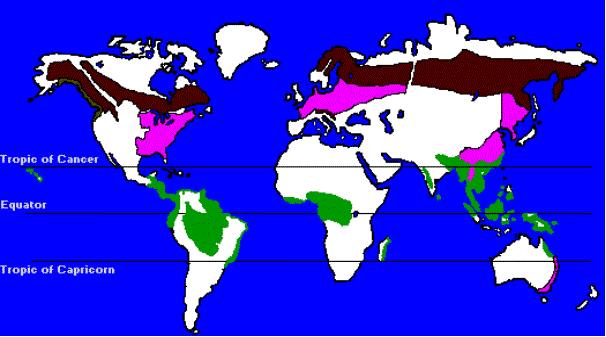
When we use the term "tropical" we refer to the area between the Tropics of Cancer and Capricorn. Because this region of the earth receives the most "direct" rays of the sun throughout the year, the temperatures usually stay fairly warm.
Between the Tropics of Capricorn and Cancer, there are many types of forests such as: Moist Tropical Forests, Dry Tropical Forests, Riverine Forests, Mangrove Forests, and Cloud Forests.
There are many factors that influence the forest type. This is true even with a specific forest biome (rainforest, coniferous, etc.) Forest type varies by rainfall, temperature, and type of soil, animal life, and the number of dry months, altitude, and slope. For example, short scrub forests grow in tropical regions with little rainfall. Mangroves grow along shorelines where fresh river water and seawater mix together. In high-altitude mountainous areas, coniferous forests and cloud forests (in the tropics) can thrive.
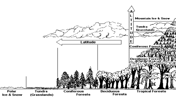
The figure below shows how forests ecosystems change as Latitude and Altitude increase
Poles Eqator
Defining the boundaries between types of tropical forests can be difficult. For example, with an increase in altitude, a tropical rainforest may gradually blend with cloud forest. As a forest nears the shore, it may slowly become dominated by mangrove forest. Therefore, the term "tropical rainforest" is sometimes just an easy way to refer to a variety of different habitats that exist between the tropics of Cancer and Capricorn. Overall, tropical forests cover about 1,700 million hectares, an area about the size of South America.
Commercial forestryCommercial forestry is currently undergoing radical changes with regard to technology and control. It has major ecological impacts through: logging native or old growth forests; intensification and management of other forests, including establishment of plantations; and through the side effects of the paper and pulp industry.
Countries with large plantation programs, such as New Zealand, Portugal, Spain and Chile, are becoming increasingly important on the world stage. Other countries are increasing the rate of cut to keep up with cheap exports of plantation timber or to develop domestic industries, an example being the rapid increase in felling in Canada's British Columbia. As tropical hardwoods are exhausted, companies are increasing their holdings in temperate countries.
Clear felling also increases risks of soil erosion, watershed destruction and ecological impacts, and driving roads into forests is identified as a particularly damaging side effect of forestry operations. Old growth logging looks set to decline, if only because of resource depletion. There are also increasing controls in some areas, and cheaper alternatives are becoming available. Although many countries have some controls on logging, these are generally inadequate to provide sufficient environmental protection. Saving remaining areas of old growth forest is identified as a conservation priority with respect to temperate forests.
Paper and pulp production The world market for pulp has increased by five times over the last forty years and it is now the major use of timber from intensively managed forests and plantations. Pulp is important both because of the total area of forest required and due to the highly polluting milling and bleaching processes, which release both air pollutants and highly toxic dioxin into water, causing damage to health and forcing the abandonment of fisheries in some areas.
Fuel use and forest lossAnother significant cause of forest degradation is the use of wood fuel and charcoal, which is currently the primary source of fuel for over 2 billion people, mainly but not exclusively in the South.
The impact of fuel wood collection on forest loss. Estimations of the importance of fuel wood in forest loss differ from seeing it as a major cause of deforestation in parts of Asia and Latin America to viewing it as a secondary cause following agricultural clearance. Searching for fuel wood is certainly a time consuming and frustrating job for many people, principally women, in developing countries such as Nepal and India. When fuel wood is in short supply, dung is dried and used as fuel, thus reducing soil fertility. However, some early analyses of the fuel wood "crisis" have proved overly pessimistic.
There have been three main responses to the perceived wood fuel crisis: establishing tree plantations; introducing wood stoves; and substituting fuel. None of these have worked particularly well to date; they have generally benefited the better off people in communities and left the poorest and land less even worse off then before. Use of wood stoves, for example, by no means always reduces overall fuel wood consumption. Alternative methods of using plant material as fuel are being investigated, including pyrolysis, gasification and use of methane digesters; however these all pose social and environmental problems of their own.
The continuing use of wood fuel as an energy source points out the need for cheap and sustainable alternatives, and various biomass energy technologies probably have a role to play here. However, such developments must also take place with full care that the environmental consequences have been carefully assessed and any problems minimized.
© commgeog@yahoo.com